Two centuries at one cove

The History of Widow’s Hole

Six chapters — a widow’s name, a whaling harbor, a working shore, an oil terminal, a gift, and a cove come full circle.

Chapter I

The Widow and Her Hole

Every “hole” on the American coast — Woods Hole the most famous — is an old sailor’s word for a small, sheltered place where a vessel can tuck in out of the weather. Greenport’s hole took its name, local tradition holds, from Margaret Leverich, the wife of a whaling captain who built the fine house on the little peninsula in the 1830s and then sailed off and never came home. Property records carry her name on this shore from the late 1840s; an 1887 bottom-land grant map still marks the parcel of Margaret M. Leverich beside the pond (you can see it on the maps page).

The name attached itself to everything around her: the brackish pond behind the house, the basin in front of it, and the shore between. It should be said plainly — the story of the widow watching for a ship that never returned is oral tradition, told consistently for generations but not yet confirmed by a dated document. The name itself, however, is as real as the deeds, charts and postcards that carry it.

A note on the record: no one has yet found the first dated use of “Widow’s Hole” on a map or deed. The Stirling Historical Society of Greenport and New York’s historic-newspaper archives are the most promising places to look. If you know something, we’d love to hear it.

Chapter II

A Harbor Built by Whales

Greenport was a deep-water town before it was anything else. The village — called Winter Harbor, then Stirling, then Green Hill before incorporating as Greenport in 1838 — sent its first whaler, the Minerva, to sea in 1795. In the half-century that followed, some two dozen whaling vessels called Greenport home, a fleet that rivaled Sag Harbor’s. The water off Widow’s Hole runs forty to eighty feet deep close to shore — a rare gift, and the reason ships of every size have always been able to work this harbor.

The railroad arrived in 1844 and tied the harbor to New York City. Menhaden steamers, oyster sloops and fishing boats followed the whalers; in the Second World War the village’s shipyards built minesweepers. The little cove at the harbor’s western edge saw all of it pass its mouth.

Chapter III

The Working Shore

The shore around Widow’s Hole earned its keep. Sage’s brickyard clay went out by water; menhaden — “bunkers” — came in by the netful; and after New York State ceded the Peconic bay bottoms for shellfish culture in 1884, Greenport grew into what the newspapers called New York’s oyster capital, with as many as fourteen oyster companies and, by 1940, some five hundred people working oysters. Oystering, brickmaking and bunker fishing all touched this one small shore.

And alongside the work, always, the pleasure. The village’s Harbor Management Plan records what the postcards show: stake moorings in “the basin known as Widows Hole” — five at the foot of Brown Street, two at the foot of Clark Street — small craft tied to stakes, a practice already generations old when the plan was written and continuing today. The basin the boats lie in was made by human hands over many years: wooden bulkheads along the homeowners’ shore, a rubble stone breakwater at the mouth, a small dock, and the sand spit the tide built behind the stones.
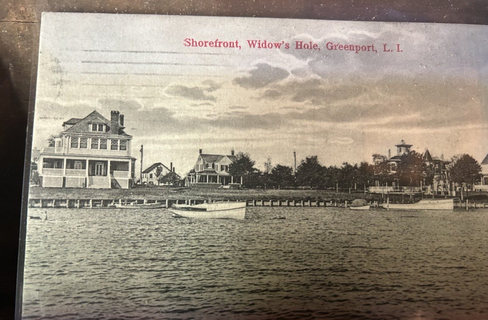
Hand-colored postcard, Shorefront, Widow's Hole, Greenport, showing bulkheaded shore and large houses
postmarked 1908 — “Shorefront, Widow’s Hole.” The wooden bulkheads lining the shore are already old news in the earliest postcards of the cove — the shorefront was engineered for boats more than a century ago.

Making the basin: bulkheads and stone

The postcard record lets us watch the basin take shape. Cards postmarked 1908 show the bulkheaded shore and boats on stakes; cards postmarked 1938 and 1942 show the rock jetty standing at the mouth of the cove, with launches lying quietly behind it. Village records describe the finished arrangement — bulkheads, rubble breakwater, dock and spit — and local recollection places the jetty’s construction in the 1930s and ’40s, which the postmarked cards bear out. The jetty page lays out the photographic evidence. What is beyond doubt is that a stone barrier has guarded this entrance for the better part of a century.
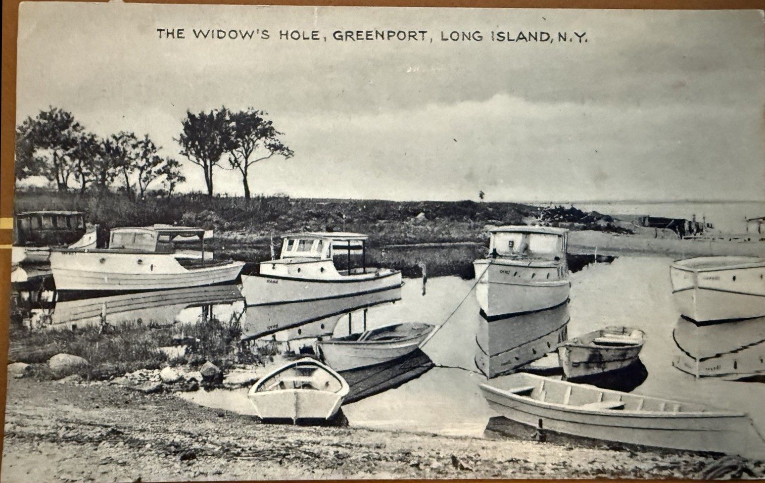
Postcard of many motorboats moored and hauled at Widow's Hole, 1920s-1940s
1920s–1940s — The gasoline age fills the Hole: cabin launches on moorings, skiffs on the beach, dinghies at the stakes. One postcard back from these years calls the cove a favorite rendezvous “for visiting mariners.”

Chapter IV

The Oil Terminal: The Mobil & ExxonMobil Era

In the 1920s the industrial age arrived in earnest. On the 2.31-acre parcel between Clark Street, Fourth Street and the harbor, a bulk fuel terminal rose: six above-ground tanks holding from 46,000 to 329,000 gallons, a warehouse, fuel racks and pumps, piers, pipelines and some six hundred feet of bulkhead. Fuel arrived by water and left by truck, warming North Fork homes and fueling Greenport’s fishing fleet for six decades. Mobil Oil ran the terminal; after the 1999 merger, title passed to ExxonMobil. (Who built it in the 1920s is not named in the public record.)

The terminal went out of service in the early 1980s, and its structures were demolished in the 1990s. Then came the long cleanup, documented in the state’s spill-program files: an underground tank and contaminated soil removed in 1990; a vacuum-extraction groundwater system run from 1992 to 1997; a final hot-spot excavation in December 2003 that carried away 194.5 tons of impacted soil. The DEC closed the case in July 2010, finding that neighboring wells were clean and the small residue would degrade naturally. ExxonMobil stated at a 2012 public hearing that it retains liability should any future contamination be found.

Chapter V

The Gift and the Restoration

In March 2012, ExxonMobil announced it would donate the parcel — valued at $1.4 million — to the Peconic Land Trust. The village debated it that spring, worried over lost taxes and lingering pollution; the deal closed on December 7, 2012, with a conservation easement held by the Town of Southold forever prohibiting development. Weeks before the closing, Superstorm Sandy tore away half an acre of the shoreline — so the Trust’s first gift was a wounded one.

What followed became a landmark: after years of volunteer cleanups and planning with Cornell Cooperative Extension, the Trust built the first living shoreline in the Peconic Estuary. In April 2019 crews regraded the shore with clean sand over a buried rock toe and a cobble band; that spring, volunteers planted nearly ten thousand locally-grown plants — beach grass on the dune, Spartina in the new marsh. On June 10, 2019, Greenport Elementary fourth-graders planted about two thousand of those marsh plugs with their own hands. The full story is on the Preserve page.

Chapter VI

Full Circle: The Cove Today

Stand on the preserve beach today and the scene rhymes with the oldest postcards. Small boats ride the village’s stake moorings. Kayaks winter on the sand. Beach grass holds the new dune, the young salt marsh fills with killifish and fiddler crabs, and oysters — the harbor’s old trade — are farmed once more in the waters off the captain’s house. The Shelter Island ferry still crosses the view, exactly where a 1950s postcard caption pointed it out.

Two centuries in, Widow’s Hole remains what it has always been: the village’s own little harbor — a place of recreation, refuge and togetherness, passed from one generation of Greenport boaters to the next.

Widow’s Hole at a glance

A timeline